Wednesday, March 11, 2009

Preview of NEW National Atlas Wall Map Cities Placefile

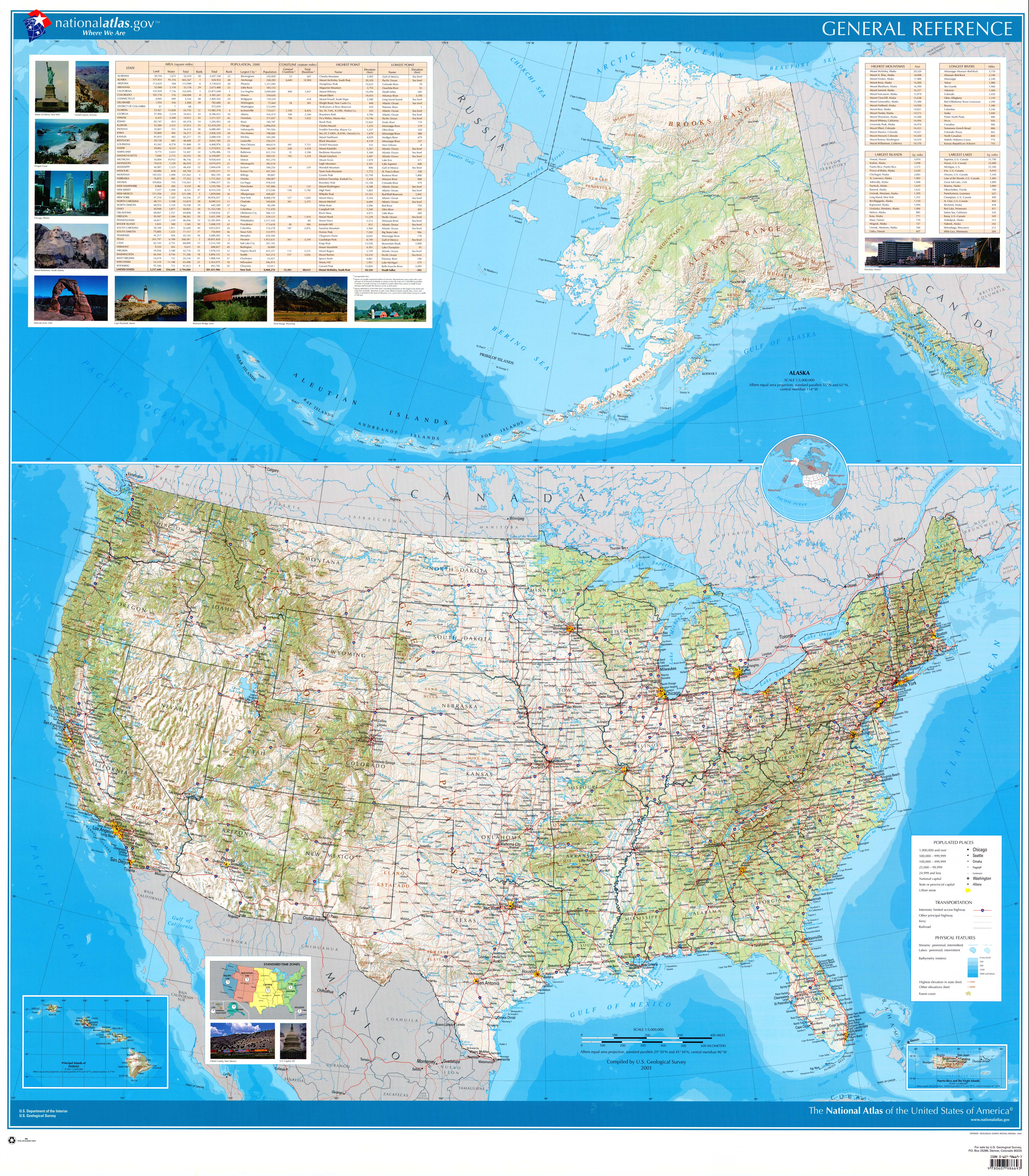
I'm posting a preview of a placefile which I'm actively working on right now. The placefile comprises every labeled city/village on the National Atlas's United States Wall Map (high-res). Unlike the previously posted file, the lat/lon coordinates used in this placefile match the city coordinates used by the GRLevelX apps. The following states are completed: Arkansas, Connecticut, DC, Georgia, Illinois, Indiana, Iowa, Kansas, Kentucky, Michigan, Missouri, Nebraska, Oklahoma, Wisconsin.

DOWNLOAD: Light Version. First zoom level: cities above population 100k. Second zoom level: cities above 25k. Third zoom level: all other cities, save for overlapping ones.

DOWNLOAD: Dense Version. First zoom level: selected cities above 50k. Second zoom level: all other cities, save for overlapping ones.

Saturday, March 7, 2009

U.S. State Labels


Here's a placefile containing labels for each of the fifty states.

DOWNLOAD

National Atlas Wall Map Cities Placefile


Here is a placefile made up of every labeled city/village on the National Atlas's United States Wall Map (high-res).

DOWNLOAD

NOTE: This placefile does not use the same lat/lon coordinates as those used by cities in the GRLevelX applications. A version that does, however, is forthcoming and will be posted within a few weeks. A preview of this new version is already available here.

Population-Based City Placefiles

I thought I would post these placefiles in case anybody wanted them. They contain every city in the U.S. over certain population thresholds. They have not been edited to remove or correct overlapping labels, nor do they use the same National Atlas lat/lon coordinates that the GRLevelX applications do.

DOWNLOAD: All U.S. cities above population 100,000

DOWNLOAD: All U.S. cities above population 50,000

DOWNLOAD: All U.S. cities above population 25,000

DOWNLOAD: All U.S. cities above population 15,000

DOWNLOAD: All U.S. cities above population 10,000

DOWNLOAD: All U.S. cities above population 5,000

DOWNLOAD: All U.S. cities above population 2,000

National Weather Service Radar Cities


This placefile contains all of the same cities as the National Weather Service radar pages.

DOWNLOAD (High-Res. Edition - This version is better for higher screen resolutions or larger monitors. City labels start at the first zoom level)

DOWNLOAD (Low-Res. Edition - This version is better for lower screen resolutions or smaller monitors. City labels start at the second zoom level instead of the first)

NOTE: These placefiles do not use the same lat/lon coordinates as those used by cities in the GRLevelX applications.

Experimental Placefile

I have been working on an experimental city placefile (called "City Pack") that uses a combination of the following three maps:

National Atlas United States Wall Map
Rand McNally M Series Wall Map
GeoNova United States Wall Map

For both the National Atlas and the Rand McNally maps, all cities above population 2,000 are included in the placefile. All cities above population 5,000 on the GeoNova map are also included in the placefile.

So far only four states are finished: Illinois, Indiana, Iowa, and Wisconsin. Kansas and Missouri are partially completed.

DOWNLOAD

I haven't been able to decide whether the cities at the second zoom level should be cities above population 50,000 or cities above population 25,000. Let me know your thoughts in the comments.

Check back for updates.

National Cities Placefile

This placefile was made using the national maps in the 2007 edition of the Rand McNally Commercial Atlas and Marketing Guide. It contains selected U.S. cities above population 25,000. Cities above population 100,000 comprise the first zoom level (threshold), while cities above population 25,000 comprise the second zoom level. Cities that were overlapped by larger cities were moved to lower zoom levels.

DOWNLOAD

First Post

All placefiles posted are intended for use on displays of 1280 x 800 or greater. Unless otherwise indicated, they are created using the same National Atlas lat/lon coordinates that Mike used in the GRLevelX apps.